Climatology
The main feature of the climate and geophysics of Spain is diversity. Temperatures, pressures, winds and rainfall are the most important elements tha make up the climate. These factors are also strongly influenced fby geophysical factors, as well as orientation, latitude, height and the proximity of sea.
CLIMATE FACTORS
Precipitations and humidity indices
Precipitations regimen is widely in the Iberian Peninsula
In general, the rainfall is of great variety within the Iberian Peninsula relief significantly influencing the orientation and the proximity or remoteness of the sea.
The influence of the relief is decisive in the rainfall distribution. Due to the spatial disposition of the mountain systems, rainfalls finds a barrier to penetrate inland and in the levantine region.
Rainfalls are divided in two periods: one maximun in autum and another secondary in spring, while the most dry periods are in winter and summer. The general exception is given in the occident and southern of the peninsula, where the most rainy periods are autum and winter.
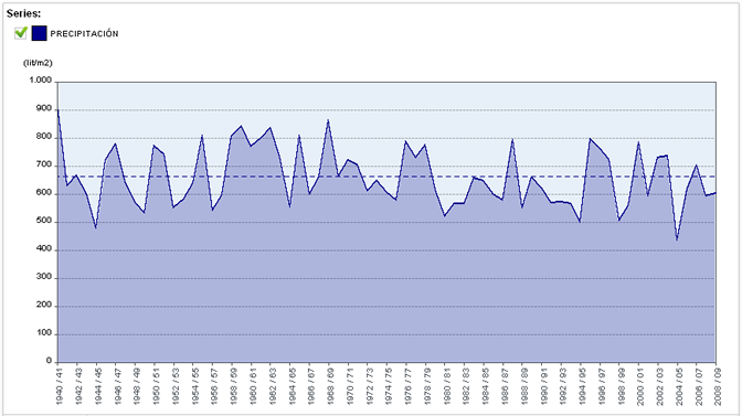
Precipitation series 1940-2008: Sistema Integrado de Información del Agua. SIA
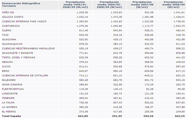
Average rainfall for River Basin District (2008): Sistema Integrado de Información del Agua. SIA
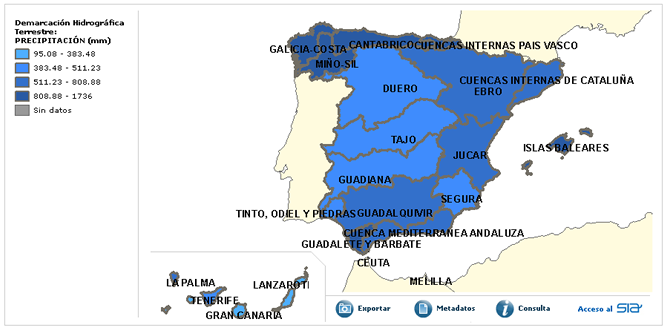
Rainfall map of River Basin District (2008): Sistema Integrado de Información del Agua. SIA
According to the humidity indice, defined like the cocient between precipitation and potential evapotranspiration of Penman, in Spain the following areas can be distinguished:
- Arid regions: part of the Canary Islands and the area of the desert of Tabernas in Almeria.
- Semi-arid: Ebro basin, Almeria, Murcia, southern Jucar, head of the Guadiana and the Canaries.
- Subhumid: Duero Basin, southern basins of Catalonia, the Balearic and Guadalquivir.
- Wet: Galicia and the Cantabrian area.
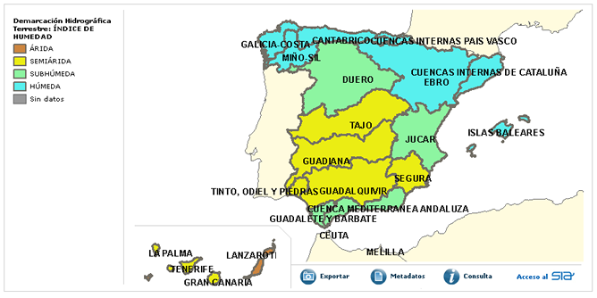
Moisture Index map for Demaración Basin (2008): Sistema Integrado de Información del Agua. SIA
To calculate the moisture content, as stated, it is necessary to know two basic parameters: precipitation and ETP. Potential evapotranspiration (ETP) is a parameter that is determined to find him some difficulty and there are different methodologies, but is useful for hydrological studies. Is determined from temperature data, actual hours of sun, wind and relative humidity.
Evapotranspiration is the loss of moisture in the ground surface produced by direct water evaporation and plant transpiration. Conceptually, the ETP is the moisture loss that would occur if the soil moisture and vegetation cover in the area of study was optimal.
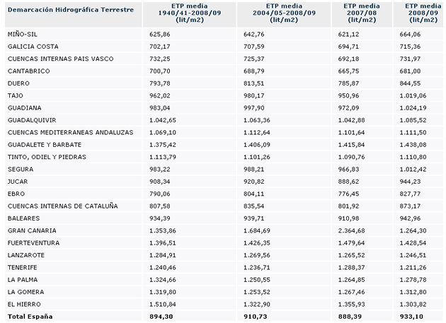
Potential evapotranspiration by River Basin District (2009). Fuente: Sistema Integrado de Información del Agua. SIA
The following graphic shows the annual average temperature from the temperature monthly averages obtained through the SIMPA model, developed by CEDEX.
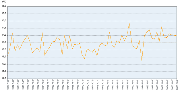
Annual average temperature in Spain (2009): Sistema Integrado de Información del Agua. SIA
The geographical distribution of the temperature in the iberian peninsula is irregular and it depends on different factors like solar radiation, vegetation, soil moisture, latitude and altitude. Generally, it can be saw an 10ºC isotherm that delimits the mountain systems from nothern half and a 12.5 ºC isotherm that marks the limit with the southern mountain area. The warmest areas in the peninsula are found in the Guadalquivir depression and in the spanish southeastern.
Taking into account the temperature distribution by river basin district, the data is represented on the map below.
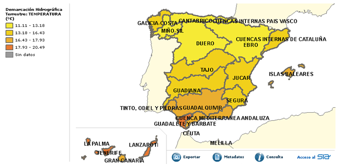
Temperature map for River Basin District: Sistema Integrado de Información del Agua. SIA
The Iberian Peninsula is in the area of low pressure or cyclonic central Atlantic and anticyclonic areas or high pressures of the central and northern Europe.
The average pressure decreases the Atlantic to the Mediterranean because of the situation of the Azores, situated in the Atlantic most of the year. Due to the geographical situation of the Iberian Peninsula presents a pressure peak in January, which descends through April. In July there is a secondary maximum of the Galician coast of Cantabria, less pronounced than before. On the Mediterranean coast is the secondary maximum from July to September. In October, we present a generalized least all the costs that will decrease until January.
January maximum is caused by the joint action of the two anticyclones, the Siberian anticyclone and the Azores. The former enters the nordesde and the second from the southwest. In the spring, the continental anticyclone disappears and is removed from the Azores to the north, allowing warm air to enter the peninsula. In summer, the anticyclone of the Azores is located in the tropical warm area. The transition from one regime to another pressure rise in most cases local storms highly infectious. The frequency coincides with the completion of the minimum spring (May-June) and end of the summer peak (August-September).
GEOGRAPHICAL FACTORS
The winds are a direct consequence of the pressures, as these are temperatures. Its mechanism is the convergence of air flows from high pressure areas to the low pressure. This phenomenon is also closely related to the relief of the land.
Spain is located away from the constant winds and contralisios trades. The winds that dominated the peninsula are within the Northeast and the West components, on the Mediterranean coast the winds from the east, north and south and narrow westerly wind prevails.
| AREAS | WIND | COMPONENT | FEATURES |
|---|---|---|---|
| Aragón y Navarra riviera | Cierzo o mistral | NO | Strong, cold in winter and dry in summer. Originating in the valley of the Ebro by the pressure difference Mediterranean-Biscay. |
| Ampurdán, Menorca | Tramontana | NE, E | Strong and cold. Use the Pyrenees as acceleration zone. Lasts up to several days with strong gusts. |
| Málaga | Terral | N | Warm in summer and cold in winter. Earth Wind causes in Málaga higher temperatures on the peninsula. |
| Cantábrico | Galernas | NO | Strong and stormy. Appears in halcyon days. The appearance of a cold front produces a sharp drop in temperature and increased humidity causes short, intense rains. |
| Gibraltar, Murcia, Alborán sea | Levante | E | Strong and stormy. Born in the Mediterranean and reaches its highest speed in the Strait. It causes dry weather on the Atlantic coast of Andalusia and fog and precipitation on the west side of the rock. |
| Extremadura and Castilla La Mancha | Solano | E | Offshore wind caused by solar radiation in summer |
| Portuguese coast | Poniente | O | Atlantic storms leads to the Iberian Peninsula |
| Meseta y Andalucía | Abrego | SO | Temperate and humid. Wind storms of autumn and spring |
| Murcia coast and Alicante | Lebeche | SO | Displacement caused by storms in the Mediterranean moving tropical air masses, warm and dusty from the Sahara. It is anticipated by haze |
| Cataluña and Baleares | Llevants | NE | Cool and moist. Provcoa severe storms at sea |
Table. Some of the most characteristic winds in Spain. Source: Authors
The Iberian peninsula is bounded between latitudes 36 º and 44 º north latitude. It is a temperate zone, with well marked stations.
Spain is the second highest country in Europe. 24% of the total area of Spain is over 1000 meters above sea level and 76% between 500 and 1000 meters.
The structural elements of the relief of the Iberian Peninsula are:
- Interior Plateau
The interior of Spain is made up of the interior plateau. Europe Between the plateaus that occupy a large area is the highest. Its average altitude is 800-900 meters in the central plains 600-700 meters north and south in the central plains. This landform relatively hinders the passage of Atlantic air masses. Within the plateau are the two mountain ranges that cross it: the Central System and the Montes de Toledo, oriented east to west with a significant parallel to the Cordillera Central, but with significantly lower elevations.
- Mountain ridges of the plateau
They consist in the northwest by the solid Galaicoduriense, on the north by the Cantabrian Mountains in the eastern part of the Iberian Cordillera mountains and Ibero-Ibero-Levantine Soria and southern Sierra Morena.
- Depressions in the plateau: Ebro and Guadalquivir
- Peripheral ridges of the plateau: Pyrenees mountains or depression Navarrese Basque, Catalan coastal mountain range and Betic Cordillera, which is the largest mountains of the peninsula with 600 km in length and average width of 200 km.
TYPES OF WEATHER IN SPAIN
The weather elements and geographical factors determine the types exposed climate in Spain. Generally describe the climates represented in the following table.
TYPE OF | LOCALIZACIÓN | TEMPERATURES | PRECIPITACIONS | VEGETATION | MAP |
|---|---|---|---|---|---|
| Oceanic | Galicia and Cornisa Cantábrica | 10º - 20ºC | Abundant | Beech, oak and chestnut | |
| Continental | Depresión del Ebro and Meseta | 25º - 13ºC | Rare and stormy summer. The most abundant in the Ebro Valley | Trees outside forests, oaks, pines, oaks | |
| Mediterranean | Zona mediterránea, atlántico andaluza, Baleares, Ceuta and Melilla | Higher in summer and mild in winter | Low and irregular | Evergreens, oaks and cork | |
| Mountain | Pirineos, Sistema Central and Cordillera Penibética | Low, with long and very cold winters. Short and hot summers | Abundant, increasing with altitude | Sparse vegetation. Pine, oak | |
| Subtropical | Islas Canarias | 25ºC - 18ºC | Scarce. The eastern islands are the driest | Canary Island pine, Canary Island palm, dragon tree |
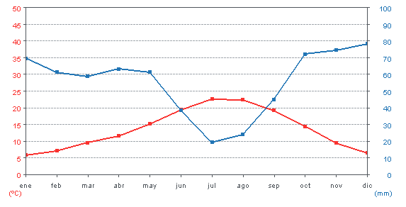
Ombrometric Diagram
Below is the diagram ombrothermic of Spain taking into account the monthly average between 1940 and 2009.
